
Congo (DRC)

Please sit down with a cup of coffee or a glass of wine, and let me entertain you with a long story of how I spent three weeks crossing the heart of Africa, from Uganda to the Democratic Republic of Congo (DRC). Although this wasn’t an easy trip, I experienced some of the most scenic parts of equatorial Africa, saw lots of birds and met hospitable, friendly people all along the way. I traveled mostly by bus and boat. To be precise, I used ten buses, vans, cars and motorcycles; seven ferries, motorboats and canoes; and one airplane.
Although I’d expected equatorial Africa to be hot and steamy, it was pleasantly cool and dry because summer is the dry season in between central Africa’s two wet seasons, and I was above 1500 meters elevation most of the time. Climate change doesn’t seem to have come to central Africa … yet.


I started my journey in Entebbe, crossing the north end of Lake Victoria by ferry. Lake Victoria is the third largest lake in the world, after the Caspian Sea and Lake Superior. The Ssese islands are a small archipelago in the northwest corner of the lake inhabited by fishermen.

At certain times of the year, Lake Victoria can be stormy. Strong winds create high enough waves to enable people to surf along the sandy coasts. On the day of my crossing, the lake was as smooth as …. well … a lake.


I spent three nights on this island. Here’s my beach bungalow at the Mirembe Resort Beach Hotel and the view from my doorstep. This island is unknown to western tourists. The Ssese Islands are where Ugandans living in Kampala come for their weekend getaways.

Much of the island is forested, with good hiking trails. When walking in the forest early one morning, I recorded the audio track above. Click the play button and count how many different kinds of birds you hear.


Fishing is the main employment and source of income in the Ssese Islands. When the weather is rough, the fishermen drink and play Parcheesi. In their spare time, they do other things that aren’t good for their health. 30% of the population of these islands is HIV positive, compared to 6% nationally. Local health officials explained to me that these islands have four systemic problems: The fishermen have a lot of free time. They’re homeless, so they sleep in different beds every night. They make lots of money compared to the rest of the islanders.. Because of the islands’ isolation, they tend to be forgotten by Uganda’s national health services and the international NGOs. The HIV clinic on Bugala Island is looking for volunteers.
From Lake Victoria, I continued west across Uganda on the main east-west road, passing through countless small villages that line the highway. The video above shows what I saw for most of the way across Uganda.

My next stop was Lake Bunyonyi, a stunning lake at 2000 meters, created when a lava flow dammed up a river 12,000 years ago. This lake is one of my favorite places in Uganda. I first came here six years ago and have been wanting to return to this Shangri-La ever since. On my arrival at Bushara Island Camp, I was warmly welcomed by Eva Her camp is a rustic resort with primitive cabins, located in the middle of Lake Bunyonyi. Bushara Island has no vehicles, no hot water and not much electricity, which gives this place its charm. The camp is an eco-lodge created by the Church of Uganda, Diocese of Kigezi. Eva has been managing this place for more than 20 years.


Being a truly local establishment, the menu is all local food. Eva’s kitchen is famous for Crayfish Masala.

Birdwatching and canoeing in dugout canoes are the main activities here.


Bushara Island Camp hosts occasional civic and environmental conferences. There was a Sunday feast for 70 guests while I was there. When her guests sailed away at sunset, Eva and her crew did a farewell dance for them.

Lake Bunyonyi is not far from Rwanda, where the roads are better maintained and the buses are more comfortable. Nevertheless, Rwanda’s buses, like all African buses, are always packed. Rwanda’s mountain roads are also very sinuous.


From the Rwanda border, I descended through tea plantations to the town of Gisenyi on the shore of Lake Kivu. Across the lake in the haze is the DRC, my ultimate goal on this travel adventure. Gisenyi was my base while I researched my trip to the DRC and found a local guide to organize my visa and permits.


My entry into the DRC would be at the south end of Lake Kivu. To get there, I rode buses for two more days, stopping to rest halfway down Lake Kivu at the Macheo Ecolodge. Like the ecolodge on Bushara Island in Uganda, this is a rustic place where you feel as though you’re really in Africa — unlike some of the luxury resorts. The beer was cold, the wifi worked, the views were breathtaking and the prices are low. What more do you need?


The ecolodge organized a half-day boat tour to visit two islands and for hiking, swimming and bird watching. On Napoleon Island, I walked through a forest full of fruit bats. My guide estimated that there are 10,000 – 20,000 bats on this island. Click the audio track below to hear them “singing.”
At the southern end of Lake Kivu are two towns. Rusizi is on the quiet Rwandan side of the border. The busier side is Bukavu in the DRC. Ordinarily, it’s difficult for an American to obtain a visa for the DRC. Had I tried on my own, I would’ve had to visit the DRC consulate in Washington DC, submit my passport, pay about $150 and wait 2-3 weeks. The shortcut I took was to arrange to visit one of the DRC’s national parks. With a park permit in hand, I obtained a Visa on Arrival at the Rusizi border for $100 in 20 minutes.


Bukavu is a livelier, busier town than any town I passed through in Rwanda or Uganda. Businesses operate day and night to sustain a massive shipping operation between Bukavu and the rest of Lake Kivu. The train of men loading the barge above looks like a trail of ants.
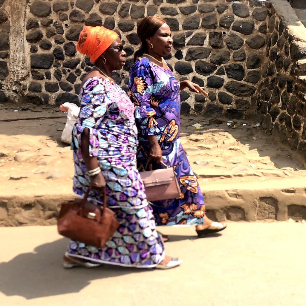


Crossing into the DRC, I noticed a change in dress styles. Congolese women like to dress up, even when they’re just in town shopping or riding the bus. I happened past the Bukavu Cathedral on a Saturday afternoon and was wowed by the attire of the women who were coming from a wedding.
There was a spontaneous wedding party on the sidewalk outside the cathedral. It wasn’t long before I was invited to join the dance.
Walking past a church later that afternoon, I was drawn inside by the rhythms and voices of a choir rehearsing for Sunday’s service. African church choirs give me goosebumps.


The primary purpose and highlight of this cross-country adventure was to visit to the Kahuzi-Biega National Park in the DRC on the western shore of Lake Kivu. This is where Eastern Lowland Gorillas can be found. This is an endangered species of which only a few hundred exist. I’d hoped to visit the mountain gorillas in DRC’s Virunga National Park and to climb Mount Nyiragongo to look down into the lava lake in its crater. Unfortunately, DRC’s Virunga NP is currently closed due to (1) Covid, (2) risk of eruption, and (3) rebel terrorism.
Compared to Uganda or Rwanda, gorilla trekking in the DRC is a bargain: $400 for foreign tourists, and $200 for students. I was impressed by these gentle giants moving quietly through the forest, snacking as they went. To protect these endangered animals from human diseases like colds, flu and COVID, visitors wear masks.

Because the Kahuzi-Biega National Park is in the DRC, it gets few visitors compared to the gorilla parks in Uganda and Rwanda. I was the only foreign tourist to visit the lowland gorillas on the day that I was there. In 2017, I trekked the Mountain Gorillas of Uganda’s Bwindi Impenetrable Forest. To have seen both groups of gorillas was a learning experience. There are significant differences between these two sub-species:
- Lowland gorillas have less hair, longer faces and are generally larger than the Mountain gorillas.
- Lowland gorillas are 100% vegetarians. Mountain gorillas eat termites and other grubs in addition to plants.
- The Lowland gorillas are polygamous. In the Kahuzi-Biega, I spent a hour with one large Silverback and his harem of three women and eight babies and juveniles. In the mountains, the gorillas are monogamous and live in packs with more than one adult male.

The day after my visit with gorillas, I boarded the ferry that goes from Bukavu to Goma at the north end of Lake Kivu.


This ferry runs twice daily with morning and evening departures. It’s a major operation. As I would soon learn, transportation in the DRC is fabulously inefficient and complicated. I was glad to have a guide who could push his way to the front of all the queues to get our tickets, travel permits and boarding passes.
Once on the ferry and away from the busy Bukavu harbor, the 5-hour ride up Lake Kivu was peaceful and scenic. Lake Kivu is about 80 kilometers long. In the dry summer between rainy seasons, the hills on both sides of the lake are golden brown.


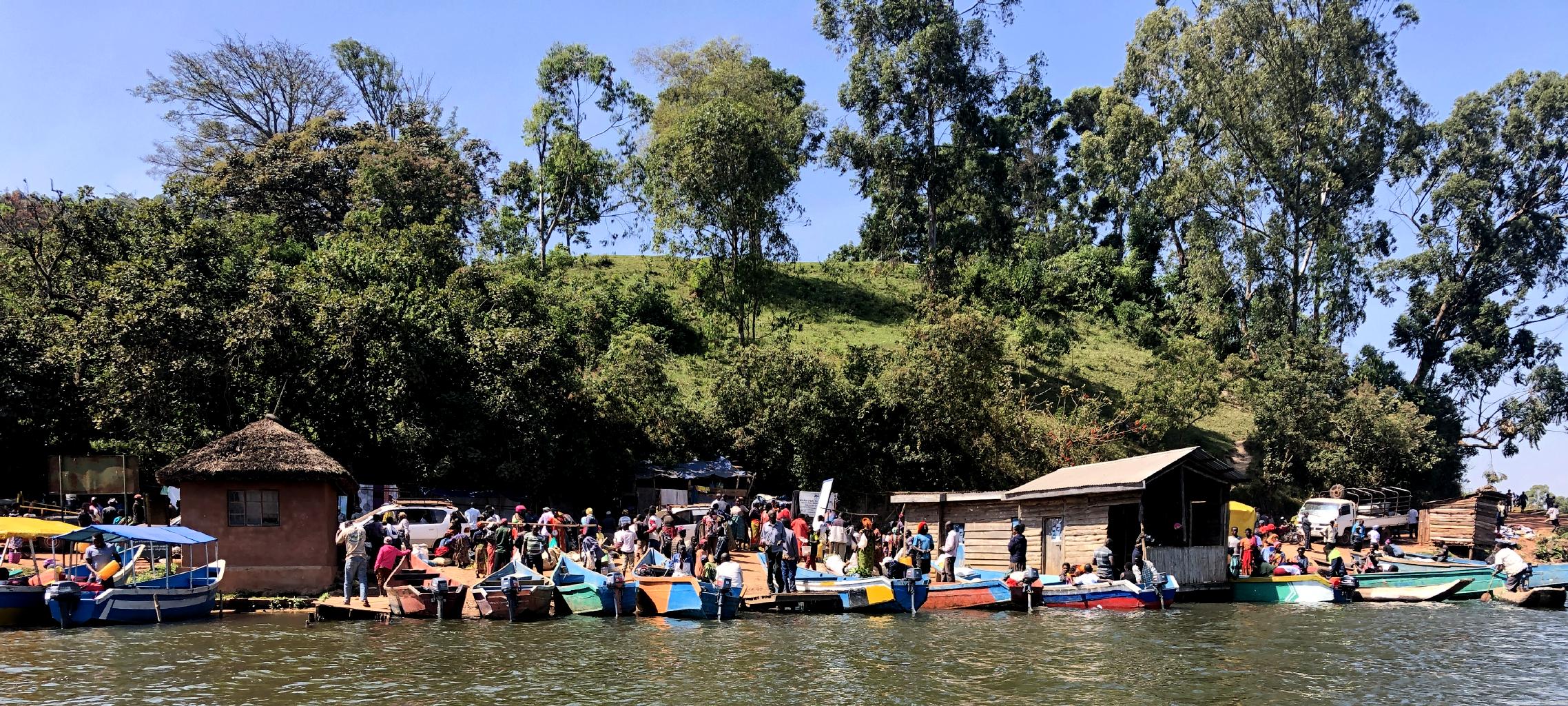
Lake Kivu is dotted with dozens of islands, many of which are inhabited by fishermen.
Shown below is my guide, Romy, to whom I owe great thanks for negotiating my way through eastern Congo. Transportation details like tickets and visas are extremely complicated in the Congo. The red tape required to board a boat or a plane in the DRC exceeds anything I ever saw in India. If you’re interested in visiting central Africa, I recommend Romy and his tour company Ubuntu Voyages tours which is based in Goma.


The last stop on this odyssey was the capital of the DRC, Kinshasa. I flew there mostly out of curiosity to see Africa’s third largest city and the largest French speaking city in the world.


My expectations for Kinshasa were low. I was not surprised to find a big, dirty, expensive city filled with monolithic government buildings and slums.


This is not a city for pedestrians. The traffic is awful and there are no crosswalks. From a friend’s advice, I asked permission of local police officers every time I wanted to take a photo.

I was appalled by garbage everywhere. After not seeing any local police, I took the photo above. Immediately and out of nowhere, I was “jumped” by three large uniformed officers who took my phone from me by force and then demanded a $1000 fee to return my phone because I had supposedly taken an “illegal” photograph. In the face of their threats to throw me in jail, I negotiated a substantially smaller bribe. After paying the bribe, the officers returned my phone to me. The fact that the “officers” didn’t ask me to delete the “illegal” photo shown above tells me that the whole episode was a fraud and a scam.
Considering that these men were large, aggressive and armed, I feel fortunate to have escaped with my phone and without injury. Nevertheless, the lesson learned is that, even in broad daylight in a public place like a market, a foreigner should tour Kinshasa accompanied by a local guide.
Travel adventures often include events like this. That’s the point of getting out of one’s comfort zone and going someplace where you don’t always know what’s going to happen next. If you never find yourself in disorienting, even uncomfortable situations like this, you’re missing out! Being scared — or at least challenged — is part of the experience.
Kinshasa gets my vote for being the dirtiest, ugliest, most dangerous city I’ve ever visited. Although I hope to return to the DRC to visit Virunga National Park when it reopens, I doubt that I’ll return to Kinshasa. On to the next adventure!
Brilliant post, Nick. You work hard to bring us along to places we will probably never go. Though you do tempt us!
Thanks for the vivid description. I enjoyed reading it.
Your encounter with the uniformed officials reminded me about my experience with the Rwanda immigration police. Crossing the border from Uganda to Rwanda. it was a long line filled with workers coming from other parts of Africa to work. I was bored waiting in line and stupid enough to take a photo of the immigration booth. Within seconds, my phone was confiscated and I was threatened not to be able to enter Rwanda. At that stage, Jason was ready to leave me to my troubles because he thought I was reckless.
Well, I had to negotiate getting my phone back from the supervisor ( A nasty looking face, full of authority…) while all the Ethiopian workers were having a blast looking at the stupid white woman misbehaving.
Be safe out there. They take this things seriously there.
Nick –
If this is not the most engaging of all the reports you’ve sent from 179 countries, it’s darn close. The sheer number of photos and videos does enhance the effect … not just because they show lots of what to some of us is exotic but because how well they’re put together on the site.
You are a terrific ambassador.
See you in a few days.
John
I have not read your blog about the country of Congo in it’s entirely but I understand Lake Kivu to be a vastly evil place. Be careful. Lisa
Wow!!! Again you brought me to church, wedding, lakes,cities, parks and the most amazing places in the world. To talk about everything you thought me on this vlog, will take me as many words as you wrote to explain them to me. Thank you
Wow! This may be my favorite story yet. What an adventure.
What a paradox: Africans in these countries seem to be wonderfully able to entertain themselves and others with spontaneous music and dance. And yet, their countries seem terribly dysfunctional and corrupt. At least the gorillas seem pretty peaceful and orderly.
My dad’s friend, Dr George Burrus, and his family were medical missionaries in the DRC in the 1960s. His wife, Barbara, wrote a wonderful memoir about their time there. At that time it was called Zaire.
I think this must be one of Mrs. Burrus’s books:
https://www.amazon.com/Shandras-Smile-Barbara-Howard-Burrus/dp/1577363558
https://www.amazon.com/Sharing-four-cultures-journey-love/dp/1577360451
Here is Barbara Burrus’s memoir about Zaire.
A Nashville friend, Joyce Jackson, has fond memories of living in Uganda when she worked for the Bahai’s. Were most of your fellow travelers from surrounding countries? Don’t sense a lot of Westerners shared your route. Scary moment in Kinshasa; did your knowledge of French get you off the hook or are there English speakers?
When you go visit gorillas, it is a really good idea to keep your phone battery charged. And, may I say, if I have not already, you are very, very good at handheld cinematography. Not easy.
Watching gorillas while listening to choir music is a hell of a way to have your coffee.
I wonder how much bark and leaves a gorilla needs to eat in a day to keep going…
Nick, what an incredible journey! Your photos and videos are amazing, especially of the gorillas. And the descriptions of your adventures – wow. Again I say, You are intrepid!
Another great adventure, Nick! You’re the best, my friend.
Nick,
Thanks for the extraordinary film, various avian sounds and your commentary.
Joe
Nick –
As always, your post is fascinating. My first real adventure was “hitchhiking” across Africa in 1977. The lakeside lodges in your Uganda photos are very appealing. Plus, the video of the roadside settlements brought back many memories of Rwanda and Zaire.
I was enthralled by your video of the gorillas. I’m surprised you were allowed to get so close. We had to keep our distance from them, maybe 50 feet, when we hiked through the forest to see them the area northwest of Lake Kivu.
Thank you for post, Jeremy
Hey Nick! Wonderful reporting on the Congo. I was wondering how close you were to the gorillas when you were videoing them, and if you ever felt threatened by them.