
Nauru
Nauru receives about 200 tourists per year, which gives this island the distinction of being the world’s least visited country.
Why does Nauru receive so few visitors?
- After the Vatican and Monaco, Nauru is the world’s 3rd smallest country by area. With a population of only 13,000, there aren’t many people here.
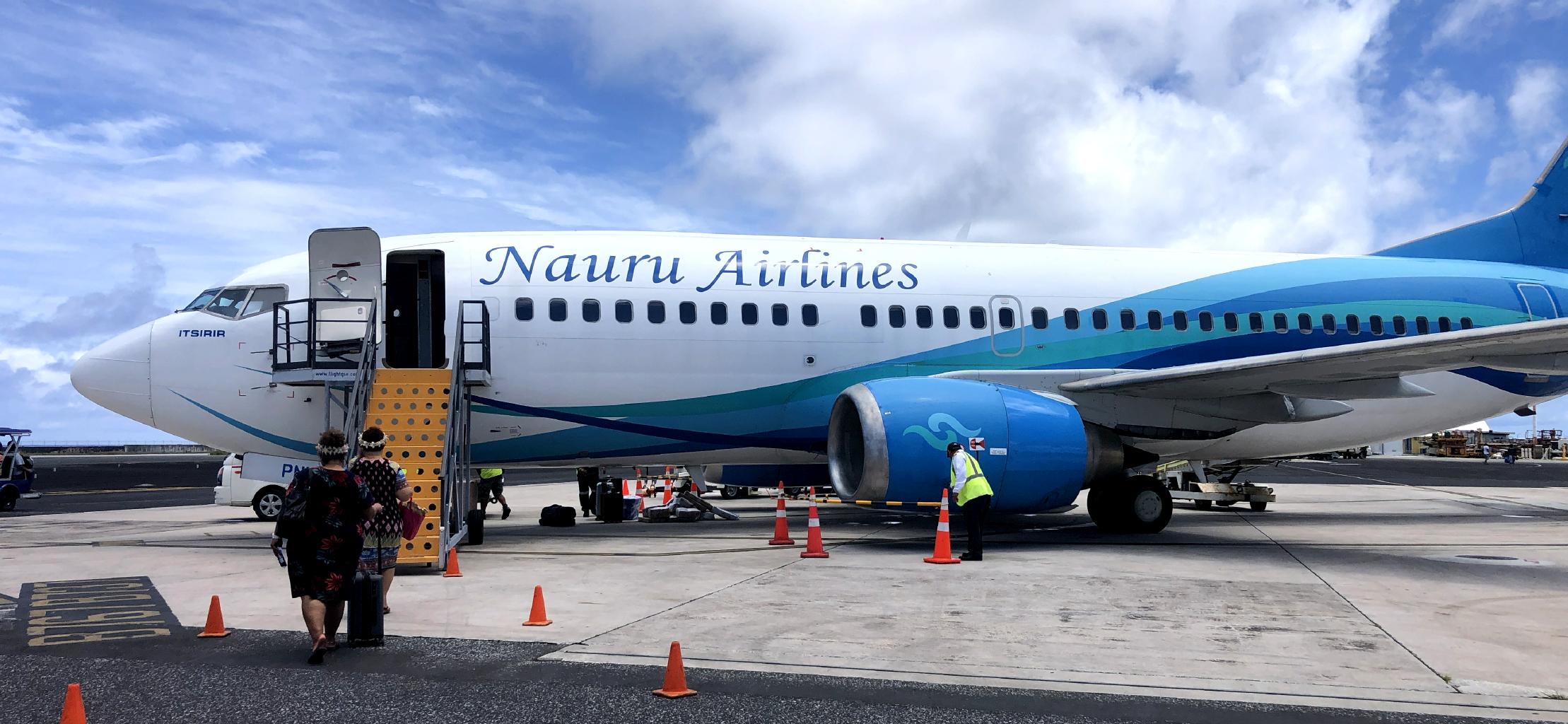
- Nauru Airways’ fleet of four 737-300’s carry limited passenger traffic with flights about once a week to and from Brisbane, Fiji and Tarawa. Not a lot of options.
- Nauru’s visa process is cumbersome. To get a single-entry tourist visa, I had to email scanned copies of my passport, my Covid vax card, my airplane tickets in and out, my confirmed hotel booking, my employment contract with the College of Micronesia, and a cover letter explaining the purpose of my visit. After my documents were accepted and approved, I had to pay $50 for my visa by international bank wire.
- Foreign journalists are especially rare in Nauru. The visa fee for journalists is $8,000. If your visa is denied, you wont’ get your $8,000 back .
- Finally, there’s not a lot to do in Nauru. The main activity is/was phosphate mining, which I’ll say more about below. Keep reading.
So, why would anyone bother to come to Nauru? Another guy got off the plane with me who looked like a tourist, so I asked him. He told me he came to Nauru because he wants to visit every country in the world. Tom turned out to be a member of Every Passport Stamp …. just like me!

Flying into Nauru, I had a perfect window seat to view this tiny island nation. How small is Nauru? It has the same area (21 km2) as St.Barts in the Caribbean. You could also think of Nauru as being a little more than twice the size of Michigan’s Mackinac Island. In one day, I hiked Nauru’s entire perimeter, visited all 12 of its provinces, climbed its highest peak, and went swimming on both its north and south coasts. You could run a hill-less marathon here by doing two laps around the island. Take plenty of water because it gets hot in the middle of the day. Nauru is only 42 kilometers south of the equator and there’s little shade.


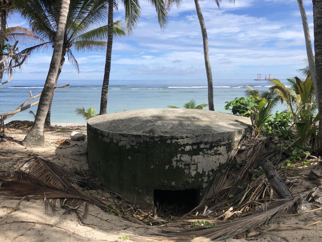
Nauru has a few historical landmarks I was curious to see. During World War II, Nauru was occupied by Japan. U.S. forces chose to bypass Nauru during their reconquest of the Pacific. So, most of Japan’s defenses are intact. There are undamaged bunkers every kilometer or so around the island.

Commando Ridge, elevation 65 meters, is the highest point on the island. There are Japanese guns up there, surrounded by extremely rugged terrain. I skinned my knees climbing and hiking through these sharp pinnacles. The interior of the island is a hiker’s nightmare.
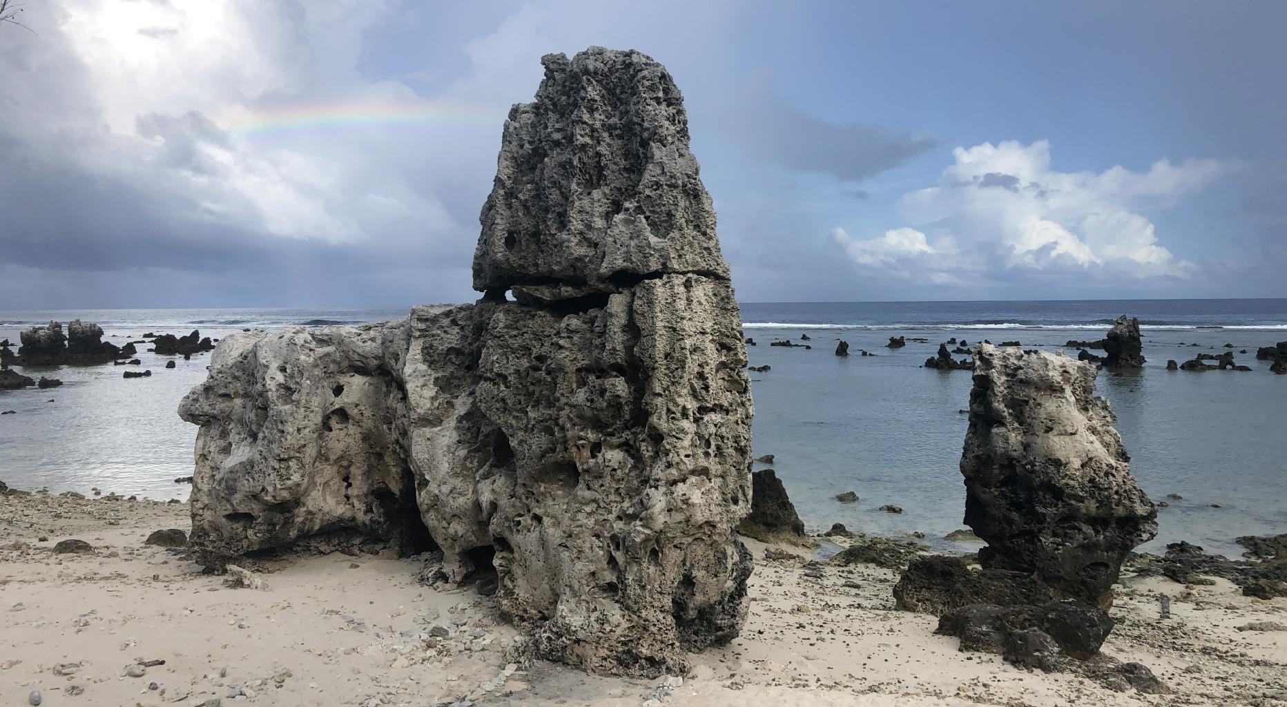
Like the interior, many beaches are decorated with jagged limestone outcrops formed from ancient coral reefs.
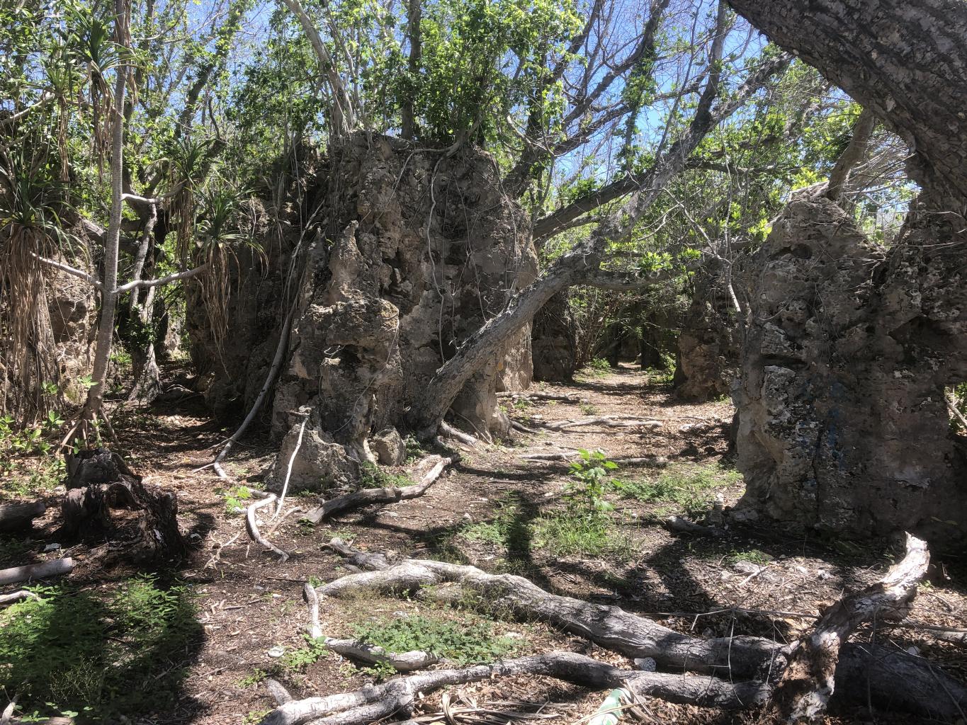
Parts of Nauru’s interior are a maze of canyons. The Japanese used these canyons as hiding places, and even a prison with jail cells carved into the rock.
The first Westerner to sight Nauru was a British sea captain who named it “Pleasant Island” in 1798 because of its attractive appearance and the friendly natives. Later the name was changed to Nauru, which is said to be derived from the Nauruan word Anáoero, which means “I go to the beach..” Although Nauru still has beaches, it’s not as pleasant an island as it used to be. It has become yet another victim of the Resource Curse.

Before humans discovered Nauru, this island was inhabited by millions of birds who, over thousands of years, created one of the world’s largest deposits of guano – which happens to be rich in phosphate, an essential ingredient to fertilizer and animal feed supplements. Nauru’s phosphate deposits were all on the surface, which allowed easy strip mining operations.
Mining of Nauru’s phosphate deposits began in the early 20th century under a German-British consortium. In 1967, the people of Nauru purchased the assets of the British Phosphate Commissioners. In 1970, control passed to the locally-owned Nauru Phosphate Corporation (NPC). For a couple of decades, Nauru’s phosphate business boomed. Income from phosphate mining made Nauruans among the richest people in the world with GDP peaking in 1981 at $27,000 per person.

Phosphate mining stripped more than 80% of Nauru’s land, leaving its interior a badlands filled with jagged limestone pinnacles. Fauna is sparse on the island because of a lack of vegetation. 40% of marine life has been killed by silt and phosphate runoff. Much of the groundwater has also been contaminated by mining, forcing Nauruans to rely on imported water,. Nauru’s native soil was removed by mining activities. Most foods must be imported because of the loss of 90% of tenable land, leaving people with a diet of processed foods, such as rice and sugar. Diabetes and obesity are major health issues in Nauru.

By the 1990’s, Nauru’s phosphate reserves were almost entirely depleted. So, Nauru’s government started looking for alternate ways to maintain their income stream:
- During the 1990’s, Nauru was a hotspot for money laundering activities. Banks were created which existed only on paper. Customers’ identities or where their money came from were not recorded. An estimated $80 billion was laundered by Russians through Nauru’s shell banks. Although these shell banks were shut down in 2004, Nauru remains a tax haven.
- Nauru used its membership in the United Nations to gain financial support from both Taiwan (ROC) and mainland China (PRC) by changing its recognition from one to the other under the “One-China Policy.” In 2002, Nauru signed an agreement to establish diplomatic relations with the PRC, accepting $130 million from the PRC for this action. In 2005, Nauru re-established diplomatic links and political support for the ROC for an undisclosed sum. In 2009 Nauru became the fourth country, after Russia, Nicaragua, and Venezuela, to recognize Abkhazia. Russia reportedly gave Nauru $50 million in humanitarian aid in exchange for this recognition
- Nauru receives significant income for assisting Australia’s “offshore processing” of refugees. When Australia intercepts a boat full of southern Asians trying to enter Australia illegally, the captured refugees are transferred to Nauru and housed in an Immigration Detention Facility. On a recent flight, I was seated next to two Australian immigration officers who had just deported someone. They assured me that there were now only 12 refugees left in Nauru’s detention camps. They also warned me not to take any photographs of these facilities . The photo below is the sort of photo that journalists aren’t allowed to take.

Nauru is a classic example of the “Resource Curse.” For thousands of years, Nauruans lived in balance with nature, isolated but self-sufficient. Although there were often tensions between Nauru’s 12 tribes, if there’d been no phosphate deposits on Nauru, this little island might have remained a pleasant place. Instead, with almost no vegetation, a gigantic open pit mine, and huge trucks and cranes gathering dust, Nauru reminded me of a ghost town in the Old West.
I should add that all the Nauruans I met here were friendly and helpful — maybe because they get so few tourists. They spoke excellent English with Australian accents. I stayed at the Ewa Lodge, which had hot and cold water, excellent A/C and hi-speed internet, and was upstairs from the best grocery and liquor store on the island. Still, after three days in Nauru, it’s time to move on to someplace more vibrant and green.
Such a sad story, Nick. I found it surprising that there were as many as 13,000 inhabitants in such an inhospitable place.
All I can think of, is what a wild place to set a movie that needs a grim never-before-seen setting. I hope no one finds any resources at my house, other than good food.
All I can think of, is what a wild place to set a movie that needs a grim never-before-seen setting. I hope no one finds any resources at my house, other than good food.
Nice write up!
Thanks for the great post. I have read its nearly impossible to get a visa to Nauru. . I have been somewhat following in your footsteps. I had read your posts on west Africa then traveled there myself. Earlier this year I visited French Guiana and Suriname. Nauru and Kiribati are on the list. I’m only at about 130 and a member of the Travelers Century Club. Currently in Alaska for June. Pakistan in Sep/Oct then Uganda in November. Planning 5 Stan’s for next year along with Tibet. Be safe my friend. Keep those stories coming. David
Keep in truckin’, Nick. I think you’ve almost got every country, no?
Thanks Nick for saving me a visit to this desolate island nation! How sad!
Hi Nick,
Thank you for sharing your travel posts. Yes, its sad what I read about this country.
Keep us informing, good travels.
I am your follower of West Africa journey, very soon there will be my next segment to this region.
Aya
My taxi driver yesterday in San Diego was from Pakistan. He left there 11 years ago because he lived on the border of Afghanistan, controlled by the Taliban. He smuggled via Thaliand and Micronesia to Australia where he was processed at Christmas Island then transferred to the prison (“detention center”) on Nauru. He was held there SEVEN YEARS in very terrible conditions. My Australian psych friend was offered a job there at $20,000 a month but she refuses the jab, so they withdrew the offer. Disgusting Australian policies all around. Thanks for the photo.
Another thought, if there are 13,000 inhabitants, I would guess most of the adults are working for the prison/refugee center there as guards and social service support. So it is hard to believe only 12 refugees are being houses there.
Nick –
I look forward to your blog updates since they’re always educational for me.
–Jeremy